

January 28, 2026 - Conditions Report with Mitch Sulkers
After the Drought!
It’s been more than two weeks with no measurable snowfall in the Sea-to-Sky, and weather prognosticators have happily informed us that a change is in the works. For those who have been waiting to get beyond the boundaries and away from frozen crusts and rain runnels, this is good news. At least one trick is in understanding how this new snow will sit on existing surface conditions…
Caption: Photo of alpine terrain in Whistler this week. Note widespread rain runnels, icy surfaces, and avalanche debris
Concern #1: Existing Surfaces
For the most part, solar/southern aspects in the Whistler area have a deep crust and rain runnels to 2300m elevation or more. In steeper areas, regular start zones, there are long, smooth avalanche bed surfaces from the last event. These will not provide a good bonding surface for new snow, a little like dropping feathers on a tilted ice surface. To make things even more spicy, where avalanche debris deposited, substantial chunks of icy debris will take a metre or more of new snow to be buried sufficiently to prevent riders from hitting “hidden” frozen hazards. Numerous red flags here…
To make this aspect even more interesting, in areas near ridge-tops locally, the combination of solar radiation and long-term temperature inversions means there are areas that are once again devoid of any snow base at all, but will likely appear to be good to go with even a thin cover of new snow…
On higher polar/northern aspects, the snow has developed a more “chalky” surface, with some facetting having occurred at times. As the initial storms are most likely to have strong southerly winds, this will be the aspect that will likely receive much of the wind transported snow. Again, in steeper start zone areas, one can expect instabilities to be common.
Also, in shaded areas on all aspects, but especially in areas around treeline, there are still pockets of surface hoar to be found. These could create a significant problem when there is enough snowfall to create storm or wind slabs over top.

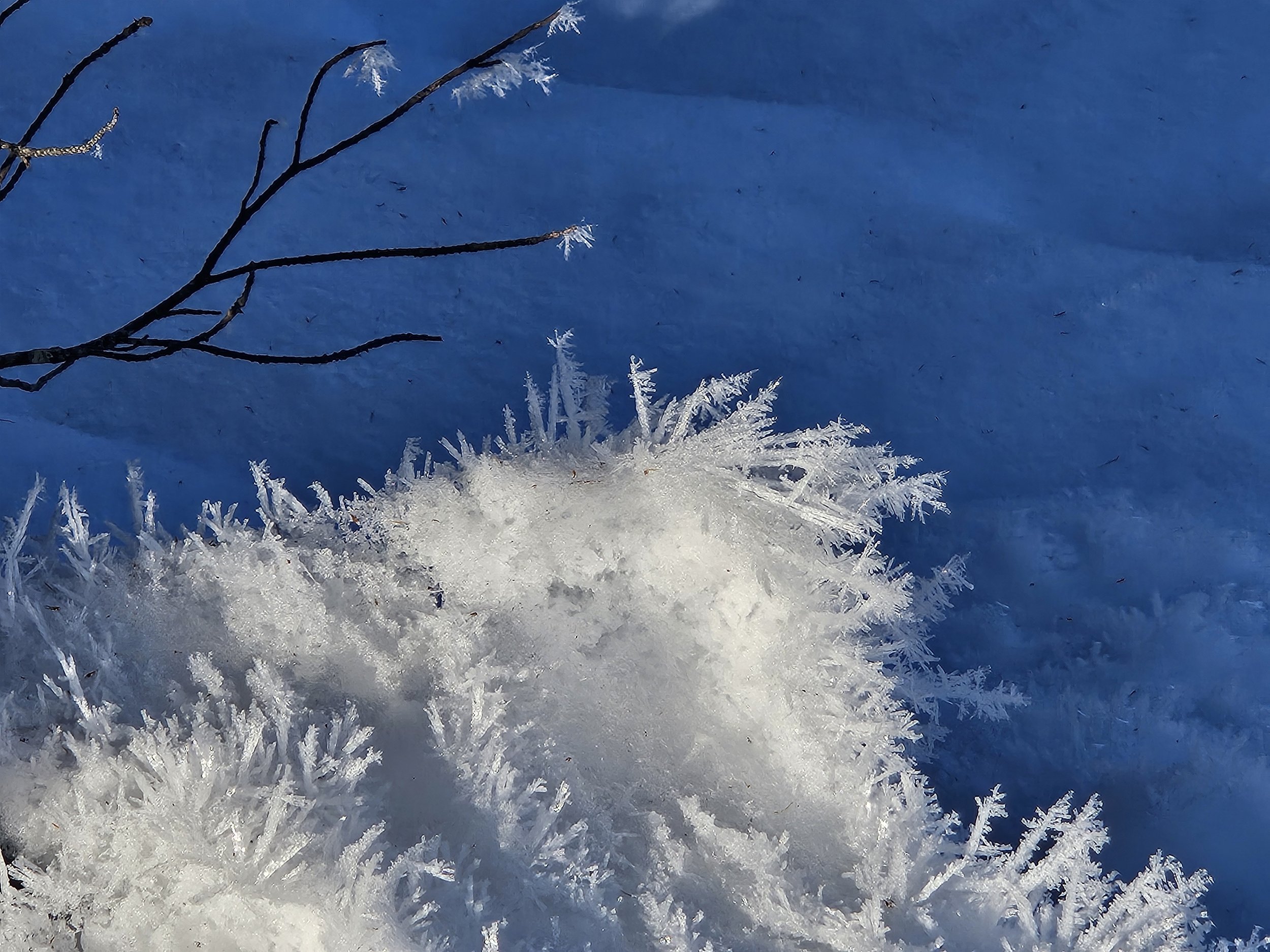
Caption: Surface Hoar to 80mm can be found in below treeline locations locally
At all aspects, from slightly above treeline to below treeline, rainfall and warm subsequent temperatures caused widespread “settlements” where creeks and depressions lay under the snowpack. Additionally, wind-created scours and pillows are now frozen in place. Hitting one of these features, with a little fresh over top, could result in serious injuries. The next couple of days will require cautious re-evaluation of the landscape.
Concern #2: Uncertain Snowfall Amounts and Fluctuating Temperatures
Currently, models do not agree on the amount of snowfall to be expected, but most forecast mild temperatures and rising freezing levels with this series of incoming fronts. When winds are above 40kph, snow will be transported across surfaces, and deposits will most likely be deepest in the lee of ridges or behind pronounced features. Even 10-15cm of new can build slabs sufficient to be very dangerous in avalanche terrain. Whistler/Blackcomb’s current weather forecast for 1800m suggests this amount may be possible both Wednesday and Thursday. Avalanche Canada’s weather forecast for the South Coast is predicting even more accumulation. It will be necessary to monitor the actual snowfall when planning how and when to enter avalanche terrain.
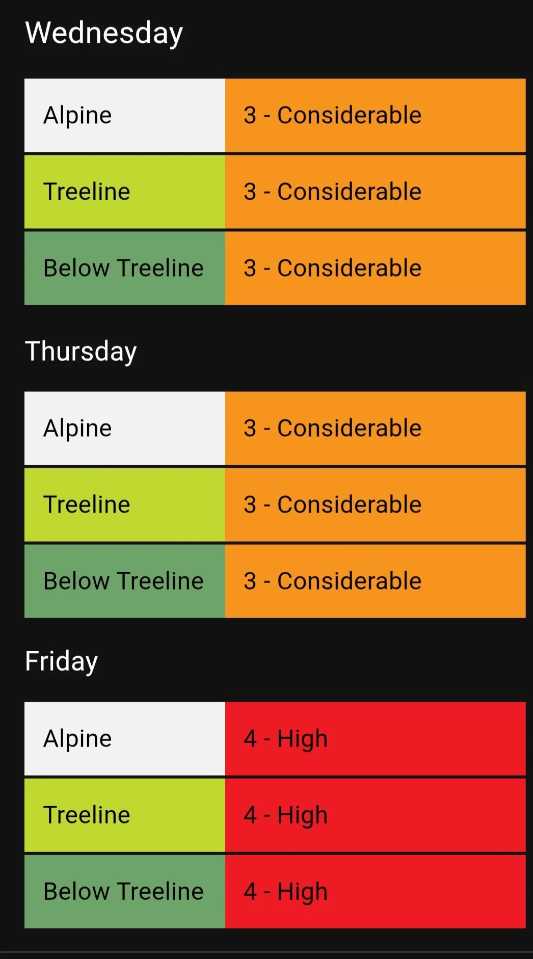
It currently appears that the warmest temperatures, though still low enough to produce snowfall, will occur on Friday. If this is the case, expect the new snowpack to develop an “upside down” density, with thicker, heavier snow over lower density. Again, this is a red flag for avalanche concerns, and helps to explain the rising avalanche danger as the week progresses, with the current forecast for avalanche danger at “Considerable” for Wednesday and Thursday, rising to “High” on Friday.
What to Do?
For the next few days, spend a little extra time reading the avalanche forecast provided by Avalanche Canada and watch the actual storm totals, temperatures, winds, and freezing levels on sites like Whistler Peak, or remote weather sites. Pay particular attention to the “Terrain and Travel” portion of the avalanche bulletin to help with your planning.
When entering mountain terrain, continue to verify actual conditions before moving into Avalanche Terrain. Start slow and mellow and keep your eyes open…